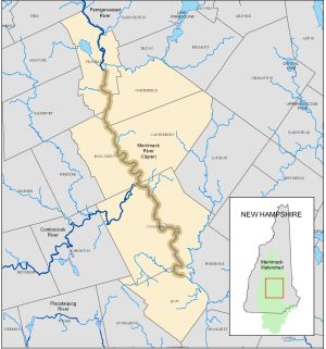
Merrimack River (Upper)
Documents and information relevant to the Upper Merrimack River LAC.
Upper Merrimack River LAC Chair:
Michele L. Tremblay, Chair
Send permit applications to:
Michele L. Tremblay, Chair
PO Box 3019
Penacook, NH 03303
UMRLAC@MerrimackRiver.net
Upper Merrimack River LAC webpage
River-front municipalities include Boscawen, Bow, Canterbury, Concord, Franklin and Northfield. To check if an address is in the designated river corridor, use the designated river mapper.
The upper Merrimack River was one of the original rivers designated in 1990 and spans 30 miles from the confluence of the Winnipesaukee and Pemigewasset rivers in Franklin to Bow. Nearly 80% of the land within three-quarters miles of the upper Merrimack River is undeveloped forest, farm or wetland. The upper Merrimack River is also eligible for inclusion in the National Wild and Scenic Rivers System.

Upper Merrimack LAC documents: Please note that these links take you to external websites.
- Upper Merrimack River fact sheet.
- Upper Merrimack River map.
- Upper Merrimack River Corridor Plan.
- Target Fish Community Assessment - Merrimack River.
-
Ammonoosuc River
-
Ashuelot River
-
Cocheco River
-
Cold River
-
Connecticut River
-
Contoocook and North Branch Rivers
-
Exeter-Squamscott River
-
Isinglass River
-
Lamprey River
-
Mascoma River
-
Merrimack River (Lower)
-
Merrimack River (Upper)
-
Oyster River
-
Pemigewasset River
-
Piscataquog River
-
Saco River
-
Souhegan River
-
Swift River
-
Warner River


